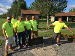
HF-L Girl Scouts pose next to their newly installed trail map (from left to right): Natalie Gilbert, Katie Montemarano, Anna Nikodem, Caitlin Kenny, Addie Beutner. Missing from photo: Sophie Eberle, Tali Camobreco, Lucy Neff, Skylar Twitchell, Elizabeth Kessler, Brie Clifford. Photo submitted by John Wadach, Village of Lima Trustee
Lima Girl Scout Troop 60383 led by Jeanne Beutner and Jennifer Kenny have created a map of the 3 miles of trails in the Mark Tubbs Memorial Park. The girls installed the large format colored map on Sunday, August 23rd in the park information board that was built by Lima Boy Scout Kyle Beiter. The map shows the name, location, and distance of each trail in the park.
The Girl Scouts learned about the historical geography of the park using Geographic Information System (GIS) mapping technology from Rob Beutner who is a registered Geo-mentor with the American Association of Geographers. The girls utilized a cell phone app to record the GPS coordinates of all trails and then overlaid that data onto an aerial map of the park.
Trail names were assigned by the scouts using historical information that they learned from John Recktenwald who was a founding father of the park. Trail names include The Yellow Brick Road and School Bus Run. The Yellow Brick Road name was chosen as this trail is located in the southeast corner of the park where an old brick factory was once located. The motivation for School Bus Run came from an old cutout school bus frame that was formerly used on the site for grazing cows to shelter in during inclement weather.
The Girl Scouts will be completing their project next spring when they install trail markers along the trail routes. The signs will have the trail names, distances, and a QR code that will bring visitors to a website with the full trail map and historical information about the park. Once the project is completed, the participating scouts will earn their Silver Award.


